

Mapping the Future with Geospatial AI Solutions
Building Smarter Geospatial Solutions with AI? Let’s Connect!
Humans are adept at interpreting geographical data; they can easily recognize topography, navigate maps, and plan routes. Imagine now using that innate ability on an unprecedented scale. In order to accomplish this, geospatial AI combines sophisticated algorithms, carefully selected training data, and large geographical datasets, providing unparalleled accuracy and power.
AI-powered geospatial solutions are transforming a variety of sectors, from deciphering complicated geographic patterns to predicting future trends and simplifying difficult procedures. In the fields of environmental protection, urban planning, and disaster response, these technologies offer unmatched precision, effectiveness, and vision, opening the door to a more sustainable and smarter future.
2B
High Quality annotations delivered
2B
High Quality annotations delivered
2B
High Quality annotations delivered
AI-Powered Geospatial Project Transformation
Discover how geospatial AI can encourage innovation in sectors like land management, urban planning, and agriculture with our customized data solutions.
Geospatial Data Annotation
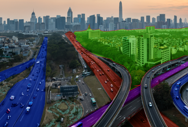
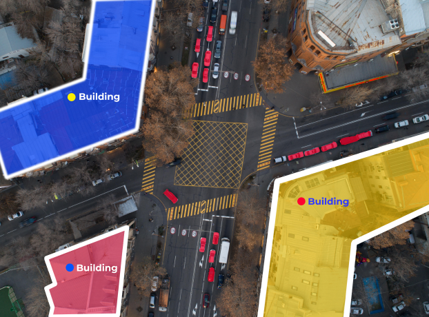
Training geographic AI systems requires precise geospatial annotation. We offer accurate labeling services for maps, satellite photos, and aerial video that are suited to intricate geospatial annotation requirements. Our geospatial data annotations allow AI to identify items, patterns, and actionable insights using sophisticated human-in-the-loop methodologies. This guarantees AI models with excellent performance for sectors such as agriculture, urban planning, and disaster relief. Join forces with us for scalable and accurate annotation solutions.
- Polygon Annotation
- Land Use & Land Cover (LULC) Mapping
- Semantic Segmentation
- Contour Line Annotation
- 3D Terrain Mapping

Geospatial Data Collection
The foundation of spatial pattern recognition AI systems is high-quality datasets. Our data collecting services use cutting-edge technologies and methodologies to collect and evaluate real-world data. Our specialty is collecting environmental inputs, satellite photos, and sensor data to build reliable AI models. Accuracy is ensured for applications such as logistics optimization and smart city applications by rigorously checked datasets. Utilize data designed for significant geographic solutions to unleash the power of your AI.
- Satellite Imagery
- Aerial Data
- LiDAR Data
- Sensor Data
Key Use Cases of Geospatial AI
Urban Development Optimization
Through the analysis of geographical data & GIS data integration, geospatial AI revolutionizes urban planning by optimizing resource allocation, zoning, and infrastructure. It gives planners the ability to predict future events, spot trends in growth, and enhance urban quality of life. AI guarantees data-driven judgments that promote sustainable urban growth in everything from smart city designs to traffic flow management. These revelations enable officials to effectively and precisely handle issues like environmental damage and congestion.
Environmental Surveillance
AI-driven geospatial technologies analyze biodiversity, utilise mapping automation and remote sensing to keep an eye on ecosystems, and instantly detect environmental threats. They use ground data and satellite pictures to identify the effects of pollution, deforestation, and climate change. This makes it possible to take prompt action to preserve natural areas and guarantee sustainability. Geospatial modeling helps the world fight environmental issues by offering practical insights. In preserving the resources and ecosystems of our world, it is an indispensable ally.
Transportation and Logistics
Geospatial AI analyzes routes, traffic patterns, and delivery schedules to enhance transportation networks and expedite logistics. Fleet management is improved, fuel consumption is decreased, and supply chain efficiency is increased. Adaptive and more intelligent route planning are made possible by real-time geospatial analytics. These technologies provide smooth mobility and operations for a variety of businesses, including ride-sharing and international logistics.
Renewable Energy Site Selection
Geographic Information Systems (GIS) is transforming renewable energy by determining the optimal sites for hydropower plants, wind turbines, and solar farms. Project efficiency and environmental friendliness are guaranteed by examining variables such as climate, topography, and resource accessibility. These insights assist developers in reducing expenses, increasing energy output, and minimizing their influence on the environment. Geospatial artificial intelligence makes renewable energy more intelligent, scalable, and sustainable.
Agricultural Management
Through the spatial data analysis of weather patterns, crop production, and soil health, geospatial AI eliminates uncertainty from farming. It assists farmers with resource management, insect control, and irrigation optimization for increased yields. From tiny family farms to huge operations, geospatial AI promotes better agricultural methods and assures food security by striking a balance between cost savings and environmental sustainability.
Satellite Imagery Utilization
The potential of location intelligence like imagery from satellites to track changes in the environment, infrastructure, and landscapes is unlocked by geospatial AI. It examines big databases to find patterns, spot irregularities, and deliver useful knowledge. National security, urban planning, and disaster management are among the applications. Geospatial AI makes it possible to make well-informed judgments that safeguard communities and influence companies by utilizing satellite data.
Why Choose Macgence for Your
transcription?

 Wide Industrial Coverage

 Wide Industrial Coverage
Macgence’s solutions span a wide range of industries, ensuring tailor-made strategies that drive success, no matter your sector.
Security and Confidentiality

 Security and Confidentiality
We prioritize the security and confidentiality of your data, giving you peace of mind while we help you unlock actionable insights.
Dataset Customization

 Dataset Customization
With Macgence, your datasets are fully customizable, empowering you with the precision and relevance your business needs to thrive.
Exceptional Workflow

 Exceptional Workflow
Our streamlined workflow ensures smooth execution, maximizing efficiency and delivering top-notch results every time.
Affordable Quick Services

 Affordable Quick Services
Get high-quality results at lightning speed with Macgence’s affordable and rapid service delivery, ensuring your business stays ahead.
Frequently Asked Questions
1. How does urban planning get better using geospatial AI?
Urban planning is improved by geospatial AI, which optimizes infrastructure, zoning, and resource allocation. By making judgments based on data, it helps regulate traffic flow, forecast growth trends, and enhance urban living quality.
2. Describe geographic data annotation and explain its significance.
Accurately identifying maps, satellite photos, and aerial videos is known as geospatial data annotation, and it is used to teach AI systems. This procedure guarantees top-notch AI models that can spot trends and offer useful information to industries like urban planning and agriculture.
3. How can environmental monitoring benefit from geospatial AI?
Remote sensing, mapping automation, and satellite imagery are all used by geospatial AI to monitor ecosystems and identify environmental hazards like pollution and deforestation. Taking prompt action to protect natural places is beneficial.
4. In what ways does geospatial AI improve logistics and transportation?
To improve transportation networks, geospatial AI examines routes, delivery schedules, and traffic patterns. By offering real-time geospatial insights, it enhances fleet management, lowers fuel usage, and boosts supply chain efficiency.
5. How is agriculture management affected by geospatial AI?
To enhance agricultural methods, geospatial AI examines soil health, crop yield, and weather trends. Better yields and sustainable farming methods are ensured by its assistance with resource management, insect control, and irrigation optimization.
We're here to help with
any questions
Get In touch
Ready to Navigate the Future of Geospatial AI?
Connect with us today to turn your geospatial vision into reality.